
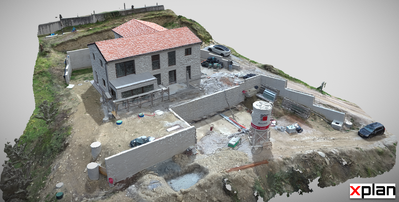
A drone 3D building model provides a useful technical and visual reference for recording existing conditions, taking measurements, carrying out checks, preparing PZI documentation, planning façade renovation, providing construction supervision and coordinating heritage conservation work. At XPLAN, we create building models using a DJI Matrice 4T drone for design, supervision and technical preparation before work starts.
Drone 3D building models for PZI, renovation and heritage conservation
A reliable record of the existing building is essential when planning façade renovation, roof repairs, PZI construction documentation, site supervision or work on protected heritage buildings. A conventional visit, a few photographs and manual measurements may not provide enough information, particularly for tall, complex or difficult-to-access buildings.
At XPLAN, we prepare drone 3D building models as an additional reference for design, bills of quantities, measurement checks, supervision, façade and roof renovation, and coordination with the Institute for the Protection of Cultural Heritage of Slovenia (ZVKDS).
A model provides a clearer spatial view of the building, façades, roof, balconies, loggias, eaves, chimneys, cornices, decorative elements and other areas that are difficult to inspect. It can help the project team understand the actual condition before work begins and reduce the risk of overlooked tasks, inaccurate quantity estimates and late coordination.
Why is a 3D building model useful?
A model is more than an attractive visual presentation. Its main value is the clearer understanding it provides before design, renovation or construction begins.
It is particularly useful for:
- recording the building’s existing condition;
- reviewing façades, roofs, balconies, loggias and difficult-to-access areas;
- basic measurements and geometry checks;
- preparing PZI construction documentation and bills of quantities;
- assessing the scope of façade renovation;
- reviewing details before construction;
- construction supervision and engineering advice;
- recording conditions before an intervention;
- comparing conditions before, during and after the work;
- coordination between the client, designer, supervisor and contractor;
- supporting architects, conservators, restorers and ZVKDS.
On larger buildings, important details are often difficult to see from the ground. Problems may only become apparent after scaffolding has been erected or work has begun. Changes are then more expensive, slower and harder to coordinate. A well-prepared model can help raise these questions earlier.
Drone models for façade renovation
A façade is not simply a flat surface with a measured area. Buildings have reveals, balconies, loggias, plinths, parapets, eaves, flashings, movement joints, canopies, fire barriers, different insulation thicknesses and many junction details.
A 3D façade model can help review:
- façade surfaces and damaged render;
- cracks, water ingress, staining and loose materials;
- window reveals and openings;
- balconies, loggias and concrete balustrades;
- cornices and plinths;
- façade junctions with the roof and ground;
- areas that are difficult to access.
When preparing a renovation bill of quantities, the model helps the team understand the scope and identify elements that could otherwise be overlooked at design or tender stage. This is particularly helpful in apartment buildings, where unit owners, the manager, designer, supervisor and contractor need a common basis for decisions.
Drone models for PZI documentation
Good existing-condition information is essential for PZI design. Inadequate surveys can lead to unclear drawings, incomplete details and gaps in the bill of quantities.
A model helps the designer understand the building’s shape, changes in level, façade offsets, complex geometry, junctions between building elements, roof condition, existing details and the accessibility of individual areas.
For energy renovation, it can support the development of solutions for façades, roofs, plinths, balconies, loggias, eaves and other parts of the building envelope. A 3D model does not replace PZI documentation; it provides an additional reference for preparing it.
Models for construction supervision and engineering
Documenting conditions before work begins is important in construction supervision. The supervisor may need to distinguish pre-existing defects from conditions uncovered during the work and changes resulting from the work itself.
A model provides a visual record that supports later comparisons. It can be used for:
- recording conditions before work starts;
- technical inspections and inspection reports;
- discussing additional work;
- checking construction details;
- communicating with the contractor and client;
- explaining technical issues to unit owners;
- monitoring progress.
For project management and engineering coordination, the model can serve as a shared visual reference. This helps reduce misunderstandings and makes technical decisions easier to discuss.
Drone models for ZVKDS coordination
Models are especially useful for protected buildings and sites where work must be coordinated with ZVKDS. These projects concern both technical renovation and the preservation of architectural, historical, design and material characteristics.
We prepare drone surveys, photographic records and 3D models to support:
- existing-condition documentation;
- reviews of façade and roof details;
- recording damage and decorative features;
- reference information for designers and architects;
- reference information for restorers and conservators;
- coordination with ZVKDS;
- archiving the condition before work;
- comparisons before and after restoration.
If heritage conditions, an opinion or further guidance require more detailed documentation of the façade, roof or individual elements, a drone model can provide a useful basis for the next stage of coordination.
It is also helpful where the existing condition needs to be recorded carefully so that the team can later identify which elements are retained, restored, reconstructed or replaced.
Use on heritage buildings
Details that are easily missed during an ordinary visit may be important on a heritage building: cornices, mouldings, stone portals, window surrounds, metal balustrades, timber elements, decorative render, roof edges, chimneys, flashings and eaves.
A model provides a clearer view of these features and supports communication between clients, building managers, unit owners, architects, designers, conservators, restorers, historians, construction supervisors, contractors and specialist services.
On complex buildings, the ability to point directly to a feature in the model is particularly useful. The discussion can be based on an actual spatial view as well as photographs and written descriptions.
What does the client receive?
The scope depends on the intended use and the complexity of the building. By agreement, the deliverables may include:
- a drone survey using the DJI Matrice 4T;
- a photographic record;
- a processed 3D building model;
- a link for viewing the model online;
- selected façade and roof views;
- images of difficult-to-access details;
- basic measurements and checks;
- technical observations;
- reference information for PZI design and bills of quantities;
- reference information for supervision and ZVKDS coordination;
- a record of the condition before construction.
For more demanding projects, the service can be combined with a review of existing documents, site measurements, a technical report, a bill of quantities or renovation advice.
Benefits of the DJI Matrice 4T survey workflow
We use the DJI Matrice 4T to capture buildings from the air and from different angles. This is particularly useful for façades, roofs, tall buildings, apartment buildings, industrial buildings and heritage properties.
Drone surveys can provide:
- a quicker initial view of difficult-to-access areas;
- less need for lifting equipment or temporary access solely for a basic visual inspection;
- better coverage of roofs and façades;
- views of details from several directions;
- images for preparing a 3D model;
- better records before work begins;
- useful information for renovation, design, supervision and heritage procedures.
The building can be viewed as a whole rather than only from ground level. This matters where damage or significant details are high on the façade or roof.
Accuracy and the limits of a model
A drone model is a useful technical and visual reference, but it does not replace every specialist service. Where official geodetic surveys, setting out, structural assessments, conservation plans or other specialist documents are required, the appropriate authorised professionals must be involved.
The model is most useful as additional information for understanding the building, documenting its condition, communicating, designing, supervising and coordinating the work.
When do we recommend a 3D building model?
Typical applications include:
- façade and energy renovation;
- roof refurbishment;
- PZI documentation and bills of quantities;
- construction supervision and engineering coordination;
- apartment buildings and heritage buildings;
- projects subject to ZVKDS conditions;
- older urban buildings;
- complex façade details, balconies, loggias and eaves;
- buildings with complex roof geometry;
- projects requiring an existing-condition record before intervention;
- projects involving several specialists who need a clear shared reference.
Example: an interactive 3D building model
The example below shows a model prepared using a DJI Matrice 4T drone. It illustrates how a building can be captured and viewed in space to support condition reviews, geometry checks, client communication, PZI design, façade renovation and heritage coordination.
Open the XPLAN 3D building model on Sketchfab.
A practical reference before work begins
Drone models support modern structural and renovation work, roof refurbishment, PZI documentation, construction supervision and ZVKDS coordination. Their main benefit is a clearer view of the actual building before implementation.
This can mean fewer ambiguities, better quantity information, clearer communication and a lower risk of unwelcome surprises. At XPLAN, we prepare models for measurement checks, design, façade and roof renovation, supervision, engineering and heritage documentation.
Are you an architect, client or engineer?
Do you need a drone 3D model for PZI documentation, façade renovation, construction supervision or heritage coordination? Send us an enquiry with basic building information, the intended purpose of the survey and any available documentation. We will propose an appropriate scope and quotation.